
TERRESTRIAL LASER SCANNING
What is it?
Terrestrial laser scanning (TLS) is a remote sensing technology for capturing extremely detailed, quantitative information about the shape or form of a surface. TLS sensors use Light Detection and Ranging (LiDAR), an active RS technology that uses either a reflected laser pulse or, less commonly, differences in phase from a continuous beam, to measure the distance to an object (often the ground surface). There are two basic types of LiDAR sensors – airborne and ground-based. Airborne systems are flown on an aircraft, and thus are capable of capturing data over a relatively wide area.
Ground-based LIDAR sensors, or Terrestrial Laser Scanners (TLS), capture data from a (or, most commonly, several) fixed position(s) on the ground. Georeferencing is usually established through the use of a known benchmark, although newer models may have a built-in GPS and altimeter. The result of a LIDAR survey, airborne or ground-based, is millions of densely-packed 3-D points, each with a unique xyz coordinate, collectively known as a point cloud. Information about the intensity, or strength of the reflected laser pulse, is also collected. In the example shown top right, points were measured with positional accuracy of 6 mm at a resolution of approximately 1 cm.
What is it used for?
There is a wide range of applications for TLS surveying. These include:
- • providing datasets for civil engineering projects
- • improving estimates of timber resources
- • characterising micro-scale features on geologic outcrops
- • studying micro-scale landform development
- • documenting archaeological sites
-
• preserving cultural heritage through the provision of extremely detailed information about a site or monument that may exist long after its destruction
How does it work?
Terrestrial laser scanners use laser pulses to measure distances to a surface. The speed of laser is known (it travels at the speed of light), so the distance to a surface can be calculated by measuring the amount of time it takes for energy from the pulse to be reflected back to the instrument. A rotating optical mirror directs the pulses over the area to be surveyed at spatial intervals specified by the user. Depending on the instrument, the scanner can record thousands to hundreds of thousands of measurements per second.
Generally multiple scans are obtained over survey area at different angles to minimise “shadowing.” Shadow zones are zones of missing data located behind some obstruction to the scanners field of view (circled in image shown right). Multiple scans over a surveyed area can be registered to a common coordinate system using survey targets (shown right) and they can be georeferenced using the GPS coordinates of targets.

Coastal Sand Dunes at Rossbeigh, Co. Kerry, Ireland

Sea cliffs, Rosser et al. (2005)
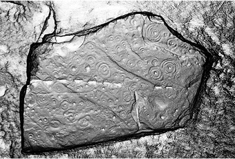
Prehistoric cup and ring carvings
Reyfad, Co.Fermanagh, Northern Ireland
John Meneely, Queens University Belfast

Shadow zones - zones of missing data located behind some obstruction to the scanners field of view, resulting in 'gaps' in the point cloud. These can be minimised by obtaining multiple surveys over the same area from different angles.

Leica HDS Target - used for georeferencing multiple scans to one common coordinate system